Contra
Costa Canal Trail is a broad path that supports a multitude of activities, including running, roller blading, dog walking, and strolling. The 13.5 mile trail runs mostly through residential neighborhoods
from Martinez to Concord, following along the Contra Costa Canal. Although
the trail crosses city streets from time to time, the Contra Costa Canal
Trail generally keeps a safe distance from roads, so users are protected
from cars (and auto exhaust). It's a perfect haven for families with small
kids and folks in wheelchairs. This cooperative project developed by the
East Bay Regional Park District and the Contra Costa Water District offers
the greatest recreational and transportation benefits to cyclists. Residents
of adjacent communities can use the Contra Costa Canal Trail to ride to
school, the grocery store, or even to commute locations via BART. Cyclists
 from out of the area may take BART to Pleasant Hill or Concord, and then
ride on the paved path to any number of parks and open spaces. Other long
distance regional trails such as Iron Horse, Ygnacio Canal, California Riding and Hiking, Lafayette
to Mount Diablo, and Briones to Mount Diablo permit passage to Mount
Diablo State Park, Briones Regional Park,
Lime Ridge Open Space, Carquinez Strait Regional
Shoreline, and Las Trampas Regional Wilderness
(note that with the exception of Contra Costa Canal and Iron Horse, all
these trails have long stretches on dirt trails and fire roads).
from out of the area may take BART to Pleasant Hill or Concord, and then
ride on the paved path to any number of parks and open spaces. Other long
distance regional trails such as Iron Horse, Ygnacio Canal, California Riding and Hiking, Lafayette
to Mount Diablo, and Briones to Mount Diablo permit passage to Mount
Diablo State Park, Briones Regional Park,
Lime Ridge Open Space, Carquinez Strait Regional
Shoreline, and Las Trampas Regional Wilderness
(note that with the exception of Contra Costa Canal and Iron Horse, all
these trails have long stretches on dirt trails and fire roads).
Numerous cul-de-sacs and streets may serve
as staging areas for a walk on the Contra Costa Canal Trail. Heather Farms
Park, roughly in the bottom middle of the horseshoe-shaped trail, is easy
to find, and provides lots of parking. You can even go for a hike or bike,
then return to Heather Farms and go for a swim (for a fee) in their beautiful
outdoor pool.
Start from the trailhead on San Carlos
Drive. The Briones to Mount Diablo Trail runs parallel to the paved
parking lot, and you can walk onto the path from either end of the lot. Walk north (away from
Ygnacio Valley Road). After less than 0.1 mile, the trail crosses the
canal on a bridge and meets a T junction. There's an information signboard
with maps here. Turn right onto the Contra Costa Canal Trail.
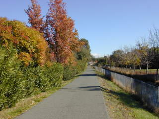
The flat and wide multi-use path heads vaguely
east. Although the Contra Costa Canal is fenced off from the trail, this
 obstacle does nothing to keep ducks out, and you'll likely see and hear
them splashing through the water. Houses are visible on the both sides
of the trail, but thick stands of mostly domesticated shrubs and trees
screen views and sounds somewhat. You might see plants ranging from natives
walnut and oak to introduced species such as pyracantha, eucalyptus, and
various pines. One distinctive tree along the trail is Arbutus unedo,
strawberry tree. This small tree has white, manzanita-like urn-shaped
flowers and round bumpy red fruit. At 0.35 mile, the Contra
Costa Canal Trail crosses busy Bancroft Road. A pedestrian activated light
ensures a safe crossing. After a long straight stretch, the trail curves
right just past a bench, and there are partial views south to Mount Diablo.
Occasionally lemons, persimmons, grapefruits, apples, and pomegranates
spill over fences out of backyards, and you might see jays munching on
fruit along the trail. These fruit trees are a riot of blossoms in spring.
School recreation fields sprawl north on the left, and you may glimpse
the rolling hills of Lime Ridge straight ahead to the east. At 1.6 miles,
there's a second street crossing, this time at Oak Grove Road. The Contra
Costa Canal Trail continues north and east, moving away from commercial
and industrial zones through residential neighborhoods. At 2.3 miles,
you'll cross quiet Citrus Avenue, and a few steps later, at about 2.35
miles, you'll reach a signed multi-trail junction. Paved Ygnacio Canal
Trail heads south, Contra Costa Canal Trail turns north, and California
Riding and Hiking Trail continues northeast. This is the turnaround point
for this walk, but consider connecting to Lime
Ridge Open Space for a picnic or hike. Retrace your steps back
to the trailhead.
obstacle does nothing to keep ducks out, and you'll likely see and hear
them splashing through the water. Houses are visible on the both sides
of the trail, but thick stands of mostly domesticated shrubs and trees
screen views and sounds somewhat. You might see plants ranging from natives
walnut and oak to introduced species such as pyracantha, eucalyptus, and
various pines. One distinctive tree along the trail is Arbutus unedo,
strawberry tree. This small tree has white, manzanita-like urn-shaped
flowers and round bumpy red fruit. At 0.35 mile, the Contra
Costa Canal Trail crosses busy Bancroft Road. A pedestrian activated light
ensures a safe crossing. After a long straight stretch, the trail curves
right just past a bench, and there are partial views south to Mount Diablo.
Occasionally lemons, persimmons, grapefruits, apples, and pomegranates
spill over fences out of backyards, and you might see jays munching on
fruit along the trail. These fruit trees are a riot of blossoms in spring.
School recreation fields sprawl north on the left, and you may glimpse
the rolling hills of Lime Ridge straight ahead to the east. At 1.6 miles,
there's a second street crossing, this time at Oak Grove Road. The Contra
Costa Canal Trail continues north and east, moving away from commercial
and industrial zones through residential neighborhoods. At 2.3 miles,
you'll cross quiet Citrus Avenue, and a few steps later, at about 2.35
miles, you'll reach a signed multi-trail junction. Paved Ygnacio Canal
Trail heads south, Contra Costa Canal Trail turns north, and California
Riding and Hiking Trail continues northeast. This is the turnaround point
for this walk, but consider connecting to Lime
Ridge Open Space for a picnic or hike. Retrace your steps back
to the trailhead.
Total distance: 4.7 miles
Last visit: Monday, November 26, 2001