The
usual welcome at an entry kiosk in the bay area is from a fee-collecting park employee. On my first visit to Coyote Hills
Regional Park, the kiosk was empty, but just past the entrance, a gray
fox sat 10 feet from the road, basking in the sun. The fox sat near the
edge of the brush and tolerated me snapping some
photos of him. A fox sighting is not an everyday occurrence, and creates
high expectations for the rest of the day. Coyote Hills lives up to any
expectations. The park's sprawling marsh teems with shorebirds, the grassy
hills are vibrant with rabbits and squirrels, and the skies are filled
with hawks, seagulls, geese, vultures, and many other birds. Views from
the crest of Red Hill are spectacular in all directions, featuring the
east bay hills (and Garin/Dry Creek Pioneer parks),
Santa Cruz Mountains, and the bay itself. The park is small enough that
it's nearly impossible to get lost, but big enough to keep a hiker or
nature lover from getting bored. With a well-signed trail system, and
 plenty of flat paths, it's a good choice for a beginning hiker, or for
folks with small children.
plenty of flat paths, it's a good choice for a beginning hiker, or for
folks with small children.
Hikes can be extended out of Coyote Hills, to
Don Edwards San Francisco Bay National Wildlife Refuge to the west and
south, and the Alameda Creek Regional Trail to the east. Inside the park,
loops range from easy to the gentle side of moderate. An under 2 mile
circuit through the marsh combines Tuibin, Chochenyo, and the boardwalk trails. This loop affords
great bird watching and skirts the Ohlone Shellmound. Nearly level Bayview
Trail provides a nice loop of under 3 miles, featuring bay and marsh views
as it skirts the park's hills. Any hike that includes Red Hill Trail is
sure to get you blood pumping, as the roller coaster path climbs to a
crest and drops sharply to bay level twice.
Be sure to check out the Visitor Center (open
Tuesday through Sunday) for exhibits and information on docent-led hikes.
If you visit on a day when the visitor center is closed, the park is usually
pretty quiet, but when the center is open on a school day you will likely
share Coyote Hills with throngs of school children.
Coyote Hills Park really shines in late
winter. Short green grass makes it easy to spot jackrabbits in the hills,
and the temperatures are mild. There aren't a ton of wildflowers here,
and so spring is perhaps best spent in the surrounding east bay
hills. By late spring the hillside grass is tall and blonde and poison
oak seems to be the only green plant. This is a nice time to concentrate
on the marsh trails, where you might see baby ducklings and geese. There
are few autumn foliage plants in the park, and very little shade.
The featured hike is a circuitous route
that I really like, visiting the marsh, Alameda Creek, and grassland.
The 5 mile hike is easily shortened by omitting the out-and-back segment
to the Ohlone Shellmound (of which it's tough to see much anyway). If
 you prefer to avoid any hills, you can skip Red Hill Trail and stay on
paved and flat Bayview all the way back to the trailhead. You can extend
the hike with a 1.5 mile loop on Meadowlark Trail, or an out-and-back
trek on Apay Way. Consult the park map for more ideas.
you prefer to avoid any hills, you can skip Red Hill Trail and stay on
paved and flat Bayview all the way back to the trailhead. You can extend
the hike with a 1.5 mile loop on Meadowlark Trail, or an out-and-back
trek on Apay Way. Consult the park map for more ideas.
For the featured hike, start at the mouth
(eastern end) of the parking lot. Cross the street and after about
215 feet, two trails begin on the left. Turn right onto the raised boardwalk section of trail (Chochenyo
Trail, to the left, is the optional route if the boardwalk and marsh are flooded).
This boardwalk path, open to hikers and cyclists, passes through the marsh,
with cattails and reeds lining the way. Birds songs
fill the air, and at the marsh's edge shy groups of geese, grebes, and
mallards may swim or fly away quickly if they feel threatened by your
presence. At 0.18 mile, you'll reach a junction with Muskrat Trail. Turn left.
After a short level stretch, turn right onto Chochenyo Trail..
Many birds splash, flap, and flutter
along the fringes of the marsh, where you might see dock, pickleweed,
and New Zealand spinach, all of which are edible. At 0.52 mile, the trail
splits at an unmarked junction. Bear left. The trail loops around
the historic shellmound area, which is fenced. As if to keep out unwanted
visitors, huge stands of poison oak shield any views. At 0.65 mile, near
a pit toilet, the trail splits again at an unsigned junction. Bear right. You'll get a glimpse into
the historic area at a locked gate. If you're interested in a closer look,
contact the staff at the park office for information on tours. At 0.8 mile, you'll reach a previously encountered junction. Bear left and retrace your steps to the connector between Chochenyo and D.U.S.T. Trail,
at 1 mile. Turn right, then right again, onto D.U.S.T. Trail.
D.U.S.T. stands for Demonstration Urban
Stormwater Treatment. According to an information sign at the junction
of D.U.S.T. Trail and the Alameda Creek Trail, this marsh was planned
and constructed by ABAG (Association of Bay Area Governments), the East
 Bay Regional Park District, and the Alameda County Flood Control District.
The marsh "is a constructed wetland designed to remove pollutants
from urban runoff storm water before it reaches the San Francisco Bay."
Surely this is a system which benefits everyone, reducing pollution into
the bay and providing an excellent outdoor experience at the same time.
The birds sure seem to love the marsh, but unfortunately, so does poison
oak, so look out for large shrubs on the side of the trail. A line of
bird boxes house tree swallows, fast moving birds with white bellies and
glossy blue caps. In late spring, the trail in lined with billowing yellow
mustard and white poison hemlock. At 1.74 miles, D.U.S.T. Trail ends at
a signed junction with the Alameda Creek Trail. Turn left onto the
Alameda Creek Trail.
Bay Regional Park District, and the Alameda County Flood Control District.
The marsh "is a constructed wetland designed to remove pollutants
from urban runoff storm water before it reaches the San Francisco Bay."
Surely this is a system which benefits everyone, reducing pollution into
the bay and providing an excellent outdoor experience at the same time.
The birds sure seem to love the marsh, but unfortunately, so does poison
oak, so look out for large shrubs on the side of the trail. A line of
bird boxes house tree swallows, fast moving birds with white bellies and
glossy blue caps. In late spring, the trail in lined with billowing yellow
mustard and white poison hemlock. At 1.74 miles, D.U.S.T. Trail ends at
a signed junction with the Alameda Creek Trail. Turn left onto the
Alameda Creek Trail.
This flat, paved trail is open to cyclists and hikers, and is part of the Bay Trail. (From the Alameda
Creek Stables Staging Area off Lowry Road you can access the unpaved trail
running on the opposite side of the Alameda County Flood Control Channel,
but there's no way to cross back over into the western edge of Coyote
Hills Regional Park.) Alameda Creek Trail is popular with dog-walkers,
joggers, and cyclists, so stay to the right and alert for traffic. The
marshy slopes of the flood control channel are lined with pickleweed,
and populated with many birds, including kingfishers and herons. I watched
and listened on a winter morning as a hawk soared over a bunch of geese
and ducks, much to the noisy displeasure of the birds on the ground. In
late spring, look for baby geese exploring their new world, with their
watchful parents nearby. Northern harriers are also common. The trail
passes a picnic area underneath some eucalyptus trees, and reaches a junction
at 2.93 miles, just past an interpretive sign about the Alameda Creek.
Paved Alameda Creek Trail continues west into the Don Edwards San Francisco
Bay National Wildlife Refuge, but take the trail to the left as
it sweeps gently uphill to a signed junction at 3 miles. Cross the
 paved Bayview Trail and take the dirt Red Hill Trail uphill.
The multi-use trail climbs through grassland.
In the late winter, look for suncups, bluedicks, and poppies sprinkled
along the lush green slopes. A surprising amount of fennel grows on the
west side of the hills,
providing homes and food for anise swallowtail butterflies -- look for
these pretty yellow and black beauties in March, fluttering about the
hillsides, perhaps accompanied by a few orange and black monarch butterflies.
On the east slope on Red Hill large thickets of poison oak add some autumn
color in the last few months of the year, and then again in the spring,
as young rust hued leaves emerge. A faint path to the left visits a rock
outcrop. Red Hill Trail crests and then drops sharply down to meet Nike
Trail at a signed junction at 3.4 miles. (If you're ready to head home,
take Nike to the left and then Bayview right to the trailhead.) Continue
uphill on Red Hill Trail.
This section features a sharp climb, tempered
with a short flat spot near a tree, then another steep grade to the park's
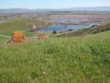
highest elevation. From here you can sit among the red boulders and watch
airplanes on their final approaches to SFO, or look out into the bay to
the Old Dumbarton Bridge and think about Harold and Maude. Bayview
Trail is visible downslope to the east. Watch what you touch; poison oak
flourishes on the hilltop. Red Hill Trail dives downhill again. Unsigned
Glider Hill Trail departs back to the trailhead on the left side of the
trail at the saddle at 3.8 miles. Continue straight on Red Hill Trail.
From the trail on one winter day
I watched a huge jackrabbit scamper back and forth from bush to shrub
on the hillside. He was so large I wasn't sure what he was at first, but
those huge black ears gave him away. Sharp-eyed redtail hawks must have
 seen him too, because three of them swept in and scoured the grass for
a good shot at him. Vultures trailed behind, hoping for any leftovers.
I (and the hawks, for now) finally gave up and I continued hiking back
uphill, to a rest stop at the picnic table on the hilltop. To the south
the hills roll toward the Dumbarton Bridge Toll Plaza. The south marsh
is visible to the east. Descend on the roller coaster trail one more time,
to the signed junction with Soaproot Trail at 3.96 miles. Turn left
onto multi-use Soaproot Trail.
seen him too, because three of them swept in and scoured the grass for
a good shot at him. Vultures trailed behind, hoping for any leftovers.
I (and the hawks, for now) finally gave up and I continued hiking back
uphill, to a rest stop at the picnic table on the hilltop. To the south
the hills roll toward the Dumbarton Bridge Toll Plaza. The south marsh
is visible to the east. Descend on the roller coaster trail one more time,
to the signed junction with Soaproot Trail at 3.96 miles. Turn left
onto multi-use Soaproot Trail.
Rabbits and ground squirrels scamper
across and around the trail as it winds downhill through the grassland.
Soaproot Trail makes a sharp curve and then at about 4.24 miles, ends
at a signed junction with Bayview Trail. Unpaved Quail Trail begins just
to the left of the junction; it heads back to the trailhead. Turn left,
then turn right onto paved Bayview Trail.
The multi-use trail passes Dairy Glen group
camping area, and continues left as another unsigned trail edges around
the south marsh to the right. California sagebrush is the dominant shrub
on the hillside. I once saw two large pheasants threading their way uphill toward the large
red rock. As the Bayview Trail curves to the north, an exposed rock face
juts out on the left side of the trail. Just past that, a spur trail (unnamed,
but well-worn and near a EBRPD sign) cuts over to the Quarry Staging Area.
(This is an option, but with so many paths carved into the hillside in
this area, it's probably best to stick to the official trail shown on
the map.) Continue straight.
Bayview Trail enters Quarry Staging Area.
Stay on the paved trail past the portable toilet, then turn left and
cross the parking lot. Near a fire road gate, look for a small
Muskrat Trail marker, and head uphill. This trail, closed to cyclists,
climbs past a covered picnic area. Poison oak is abundant, but also look
for toyon, coyote brush, monkeyflower, California sagebrush, and lupine,
which puts forth purple-blue blossoms in late winter. Before reaching
a rock outcrop, the trail splits. (If you want to visit the big red rock,
this trail back to the left along the ridgeline is the least erosive choice.)
Continue to the right on Muskrat Trail past some boulders defaced
with graffiti, then take the unsigned trail to the right downhill.
Stairs make the descent a short and sweet one. In early spring, look for
shooting stars along the trail as you descend to the trailhead.
Total distance: 5 miles
Last hiked: March 10, 2005
Previous visits: May 18, 2001 and March 13, 2000