Barbier Park is a prime hunk of Marin County real
estate with the fortuitous proximity to two other (separately managed)
parks and preserves. With the combined acreage of Barbier Park, China
Camp State Park, and San Pedro Mountain
Open Space Preserve, most of the San Rafael mountain is open space.
There is no sweat-free way to hike to the top of San Pedro Mountain --
all trailheads start from the base of the mountain, and access to the ridge is either long and moderate
or short and steep. You can reach the Nike missile site via single-track Wood Oaks Trail and San Pedro Mountain
Fire Road (trailhead off North San Pedro Road); this is generally the least-used legitimate way to the ridge.
Access from China Camp State Park is also an option, as the state park borders residential Peacock Gap neighborhoods.
It's possible to start at the end of either Knight Drive or McNear Drive and climb to Ridge Fire Road.
That fire road leaves China Camp to ascend through the upper slopes of Barbier Park,
 then reenters state park lands at a junction with Bay Hills Fire Road near the
middle of the mountain. On the south slope of San Pedro Mountain, Barbier Park
offers no facilities and just one established trailhead;
many visitors enter Barbier via neighborhood access locations where parking
can be difficult.
then reenters state park lands at a junction with Bay Hills Fire Road near the
middle of the mountain. On the south slope of San Pedro Mountain, Barbier Park
offers no facilities and just one established trailhead;
many visitors enter Barbier via neighborhood access locations where parking
can be difficult.
On bicycles visitors can traverse the entire ridge from
east to west, but hikers, who must first confront an over 800 foot ascent
in just 1.5 miles, probably won't venture that far. Once you get to the
main east-to-west series of fire roads there are some out-and-back options
to add on to an out-and-back hike, and a few loops, but if you begin from the Barbier Park trailhead keep in mind that
heading north or east very far into China Camp, or west into San Pedro
Mountain Open Space Preserve will add another long climb back to the
ridgeline on your return journey. Also note that there are many
social trails on the mountain and lots of mountain bikers, so stay alert for cyclists.
The excellent Trails of Northeast Marin County map (see links
on the left), is a very helpful guide that shows all San Pedro Mountain Trails.
Start from the end of Locust on (unsigned but obvious) Gold Hill Grade.
The initial uphill is quite rocky. The fire road reaches an unsigned junction
at 0.1 mile -- stay to the left. Gold Hill Grade crosses a seasonal creek,
then runs along a fenceline under some towering eucalyptus. An old crashed car
rusts away on the left. The fire road steps out from the trees and continues
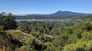
climbing, through grassland dotted with toyon, broom, and coyote brush. A bench on the left provides
a great spot to soak in the view of Mount Tamalpais and San Rafael. Then it's
back to the climb, which is steady. The trail enters a shaded woodland of
 coast live oak and California bay, where you might see coyote mint blooming in summer.
At 1 mile, an obvious trail breaks off on the left, heading across the
south face of the mountain. Continue straight/right on Gold Hill Grade.
coast live oak and California bay, where you might see coyote mint blooming in summer.
At 1 mile, an obvious trail breaks off on the left, heading across the
south face of the mountain. Continue straight/right on Gold Hill Grade.
A little redwood grove is a pleasant surprise. The
trail just keeps ascending. At 1.2 miles, Gold Hill Grade makes a sharp turn right (a single-track trail departs here -- ignore it)
and makes a final push toward the ridgeline. Views west continue to impress, extending to Bolinas Ridge.
Finally, at 1.4 miles, Gold Hill Grade ends at an unsigned T intersection with Bay
Hills Fire Road. Turn left.
Bay Hills Fire Road, a paved road, services
communications towers and runs north all the way to Bay Hills Drive.
Running along the ridge, the fire road skirts one of the communications towers, then
descends slightly. Coast live oak, madrone, and California bay trees block nearly all views.
After a bit of gentle up and down rolling, the fire road reaches a flat cleared crest, and the
high point of the hike, at 1.8 miles and 1060 feet (if you are ready
to turn back, this is a logical place to do so). Bay Hills Fire Road plummets
downhill to the north, and at 2 miles, you'll reach a signed junction, as you enter China Camp State Park.
Ridge Fire Road heads east (right), but stay to the left on Bay Hills Fire Road.
The fire road, still paved, winds through
the trees at an easy pace, then climbs a hill and levels out again. Mount
Tamalpais is visible to the south (weather permitting), and traffic noise
from US 101 drifts uphill to the ridge. At 2.2 miles (look for a guardrail
on the left), turn right into a cleared picnic area. A former Nike
radar site perches between the picnic area and the fire road, and from
there you'll have the best views in every direction, including the hills
and shoreline of China Camp, San Pablo Bay, and Mount Burdell to the north.
You can continue west on the fire road into San Pedro Mountain
Open Space Preserve, but the Nike missile site is the logical turnaround spot.
Retrace your steps back to the trailhead.
Total distance: 4.5 miles
Last hiked: Tuesday, November 13, 2001