I used to undervalue Rancho San Antonio. On my first visit, when I was a new hiker, I was appalled by the crowds. I was horrified to witness a man picking California poppies with his young
daughter (picking flowers at any park in the bay area is a no-no, and
California poppies are the state flower). I've since heard a story wherein
a Rancho regular tried to explain to a foreign visitor that the sticks
clutched in her baby's little hands were in fact, poison oak. Rancho San
Antonio may be as close as many South Bay residents (and out-of-town visitors)
get to a Bay Area nature experience. That's somewhat ironic because once
past the manicured meadows and fenced-in farm, a Bay Area hiker
may find substantial wildlife and rugged trails.
Even though Rancho's trails are heavily used by joggers and runners, quite a few visitors report
wildlife sightings, including turkeys, coyotes, quails, bobcats, and the
rare mountain lion. Deer are so common it's an unusual occurrence to not
see some. On recent hikes, I've delved into the heart of Rancho, and found
much to my liking. Although it's not a bastion of wilderness, Rancho San Antonio boasts extensive trails, varied terrain,
and easy access to South Bay and Peninsula residents.
Many visitors go no further into the preserve
 than Deer Hollow Farm, an easy flat 2 mile round trip hike. Since cyclists
are not permitted on trails west of Deer Hollow Farm, strollers outnumber
bicycles on the paths leading to the farm. Horses, though allowed on many
trails, are rarely seen. Joggers and runners make the most of Rancho's
trails; being passed by a fantastically in-shape runner while slowly trudging
uphill is a bit disheartening, but not at all unusual.
than Deer Hollow Farm, an easy flat 2 mile round trip hike. Since cyclists
are not permitted on trails west of Deer Hollow Farm, strollers outnumber
bicycles on the paths leading to the farm. Horses, though allowed on many
trails, are rarely seen. Joggers and runners make the most of Rancho's
trails; being passed by a fantastically in-shape runner while slowly trudging
uphill is a bit disheartening, but not at all unusual.
Miles of trails allow for lots of loop possibilities.
Starting from a valley elevation under 400 feet, PG&E Trail and Upper
High Meadow Trail ascend and then cross the northern slopes of Black Mountain.
Combine those paths with High Meadow Trail and Coyote Trail for a 9-mile
trek that escapes most of Rancho's crowded sections. An easier walk can
be found on Rogue Valley Trail, which departs from Deer Hollow Farm on
a level course, before turning uphill from a creekside grade to meet High Meadow Trail. High
Meadow then drops back to Deer Hollow Farm through oaks and grassland.
From Rancho's eastern trailhead, a hike to Black Mountain is possible
but tough. Expect to log about 16 miles, with elevation gain (and then
loss) of about 2400 feet. For an easier assault on Black Mountain's summit,
start at the Duveneck Windmill trailhead,
where the out-and-back trek to Black Mountain is a mere 10 mile hike.
Different seasons feature a variety of pleasant
natural phenomena at the preserve. Spring wildflowers carpet hillsides
along Hidden Meadow Trail, while in autumn the same rolling hills are
alight with the leaves of deciduous oaks. Back in the deep recesses of
Wildcat Canyon maples litter the ground with orange leaves in autumn,
and the trailside stream plumps with water in early spring. Toyon and
madrone add a festive touch of red berries around Christmas. Buckeye trees
bloom just as the majority of wildflowers fade, perfuming the air with
lovely white flowers. Then it's chamise's turn to bloom, in late May and
early June, followed by toyon. During summer heatwaves, you can seek refuge
from the heat and the crowds in the cool canyons serviced by Rogue Valley
and Wildcat Canyon Trails.
For the featured hike, start
at the county park parking lot near the restrooms. Walk down the
 paved trail at the northwestern corner. You'll cross a bridge, and
after about 125 feet, reach a junction. Turn right onto the dirt path,
marked by a sign "to Deer Hollow Farm."
paved trail at the northwestern corner. You'll cross a bridge, and
after about 125 feet, reach a junction. Turn right onto the dirt path,
marked by a sign "to Deer Hollow Farm."
The wide path, which is closed to cyclists
and equestrians, passes by a large grassy meadow, a picnic area, and skirts
a huge California bay tree. The path ends near the border of the county park and open space preserve, at 0.24 mile.
Veer left and look for the MROSD signboard. If you're pushing a
stroller or in a wheelchair, stick to the paved road all the way to Deer
Hollow Farm, but if you're hiking, choose the adjacent dirt path, Lower
Meadow Trail.
Some tall oaks and buckeyes punctuate the
grassland. Where the level trail meets the paved road, at 0.5 mile, cross
the road and pick up the trail again on the other side, as the trail
skirts a permit-only parking area. After crossing a bridge, the narrow
path, separated from the road by an old-fashioned fence, retains an easy
grade while cutting through grassland and some coyote brush. Some eucalyptus, willow, and oaks provide occasional
shade. At 0.8 mile, Lower Meadow Trail reaches a signed junction. From
here you can continue on the dirt trail, or walk along the paved road
(alternately, you can avoid the farm area by taking Farm Bypass Trail,
across the road). Stay to the right on Lower Meadow Trail, as it
takes a slight rollercoaster course through oak and locust trees. The
path ends at the paved road at 0.9 mile. Turn right.
The wide paved road follows along the creek.
Look for snowberries in autumn. Old farm implements and buildings announce
your arrival at Deer Hollow Farm. In autumn, look to the left for pomegranate
and persimmon trees. You may see some of the farm residents, including
goats, cows, and pigs. In spring, it's exciting to catch a glimpse of
baby goats, pigs, or sheep. After passing the charming garden and educational
barn, you'll reach a signed junction and information signboard at 1.10
mile. Rogue Valley Trail begins to the right. Stay to the left
(toward Wildcat Canyon Trail), as the trail continues to run along the
creek. Just past the pit toilets at 1.13 miles, you'll reach a junction
with the other end of Farm Bypass Trail. Continue straight/right. In
 late spring, you might see baby quail tottering across the
trail, watched over by proud mom and pop. At 1.24 miles, you'll reach
another signed junction. Turn right onto High Meadow Trail.
late spring, you might see baby quail tottering across the
trail, watched over by proud mom and pop. At 1.24 miles, you'll reach
another signed junction. Turn right onto High Meadow Trail.
After your flat warmup, you'll finally begin
to climb on High Meadow Trail. Along the sides of the trail, look for
monkeyflower, sagebrush, silktassel, coyote brush, pitcher sage, buckeye,
and coast live oak. Switchbacks keep the grade easy on this
trail open to equestrians and hikers only. Views to the south are revealed
almost immediately. High Meadow Trail sweeps uphill through some oaks
and grassland, with a bench under some coast live oaks creating a nice
rest spot. In late spring you might see lots of white mariposa lily, as
well as Ithuriel's spear, mule ear sunflower, and brodaiea. Wood fences
keep the trail intact as it ascends; ignore any shortcuts. You'll
climb along the flanks of a grassy knoll, a dramatic counterpart to the
aptly named Black Mountain, looming to the west. Cercocarpus (mountain
mahogany) and toyon mingle with the trailside oaks. Too soon, the trail
crests and reaches a signed junction at 2 miles. Turn left and walk
to the crest on an unmarked short path. The view from the belvedere
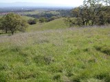
showcases the rolling foothills of Rancho, and the lovely oak grassland
you've just climbed through. This is a sure spot for spring wildflower
hunting, or a lunch break on a cool day. Retrace your steps back
to the previous junction. This junction can be confusing.
You want to continue uphill, past Wildcat Loop Trail, and then almost
immediately bear right onto a path marked with a small "trail"
marker (the other trail climbs more steeply uphill and is an option).
The trail switchbacks easily through plants often
found on the east slope of a bay area hillside; toyon, oak, monkeyflower,
and patches of poison oak. At 2.3 miles, the trail meets the steeper
fire road again at the ridgeline. Cross the fire road and stay to the
left (again, the other trail is an option). The vegetation takes a
dramatic turn on the western slope of the hillside. Drier chaparral plants
such as chamise, toyon, monkeyflower, and sagebrush are common. You can
really get a sense of how chamise dominates the landscape in late spring,
 when masses of tiny white chamise flowers brighten up the hillsides. At
2.36 miles, the two trails join together at a signed junction. Rogue Valley
Trail sets out downhill to the right. Stay to the left on High Meadow
Trail.
when masses of tiny white chamise flowers brighten up the hillsides. At
2.36 miles, the two trails join together at a signed junction. Rogue Valley
Trail sets out downhill to the right. Stay to the left on High Meadow
Trail.
The trail keeps a steady, nearly flat pace, as
it cuts through the chaparral. There are nice views north and west. At
2.68 miles, you'll reach a signed junction with Upper High Meadow Trail,
an option if you'd like to extend your hike almost 2 miles. Turn left onto Upper Wildcat Canyon Trail.
A slight descent begins on this hiking
and equestrian trail. Look for toyon, silktassel, coast live oak, chamise,
sagebrush, pitcher sage, cercocarpus, California coffeeberry, poison oak,
and madrone. If you can tear yourself away from the views and the plants,
look down at the trail. I've seen bobcat and coyote tracks, and one time
spotted a sizable furry scat that was issued forth from a large mammal,
perhaps even a mountain lion. As you lose elevation, the vegetation
begins a subtle shift. Buckeyes, madrones, and California bays herald
your arrival to the cool, damp canyon floor. This is a quiet place, where
the melodic gurgle of the creek may only be matched by the sounds of small
airplanes occasionally passing by overhead, and the pounding of joggers'
footfalls. California bay and maple tree trunks are adorned with velvet
green moss coats, and it seems as it the sun never reaches the canyon
floor. Bridges cross the creek several times, as the trail gently
descends. At 4 miles, Upper Wildcat Creek Trail meets Wildcat Loop
Trail at a signed junction. Buckeyes, maples, oaks, and California bay
mingle gracefully, with ferns, creambush, and berry bushes tangled in
the understory. Stay to the right.
The trail narrows as it winds along the
creek, remaining for the most part, under shade of California bays. At
4.15 miles, you'll reach a junction with the PG&E Trail. This trail
is an option for returning to the trailhead, although you'll face more
elevation gain and loss than returning the way you came. Stay to the
left on Wildcat Canyon Trail, which is signed as a hiking-only path.
This segment continues the enchanting journey through this spectacular
riparian corridor. In autumn, fallen buckeye seed pods resemble shiny
brown rocks in the creekbed, and orange maple leaves carpet the ground.
As you start to hike out of the canyon, the tall trees thin, allowing
sunlight to nourish the moisture-loving shrubs crowding the trail and
the creekbed. Look for ninebark, a shrub easily confused with blackberry.
The clustered flowers are distinctive. At 4.68 miles, Wildcat Canyon Trail
ends at a previously encountered junction with High Meadow Trail, near
Deer Hollow Farm. Retrace your steps back to the trailhead.
Total distance: 5.9 miles
Last hiked: March 19, 2018
Previous visits: February 5, 2013; June 1, 2001; and December 12, 2000