Skyline
Ridge features 2 all-access trails that visit the preserve's 2
small ponds. The trails around Horseshoe Lake are described on that
page; this page highlights the paths around Alpine Pond.
Start at the Russian Ridge parking lot and
head southeast toward Alpine Road. Following the signs for the Ridge Trail
and Alpine Pond Trail, descend on a gently graded dirt path past an information
signboard to a tunnel under Alpine Road. As you emerge into Skyline Ridge,
look for a currant bush to the left, lovely with pink flowers in the gloomy
early months of the year. Although the shores of the pond are dominated
 by moisture-loving plants such as willow, dock, and cattails, this stretch
of the trail is lined with oak and coyote brush. Ridge Trail levelly winds
past the other end of the loop departing to the right, and an unmarked
trail that enters from the left. Continue straight. The Daniels Nature
Center perches on the water's edge ahead; it's a fine educational pit
stop (open mostly weekends in the summer). Just past the building the
trail splits at a signed junction. Stay to the right on the Pond Loop
Trail.
by moisture-loving plants such as willow, dock, and cattails, this stretch
of the trail is lined with oak and coyote brush. Ridge Trail levelly winds
past the other end of the loop departing to the right, and an unmarked
trail that enters from the left. Continue straight. The Daniels Nature
Center perches on the water's edge ahead; it's a fine educational pit
stop (open mostly weekends in the summer). Just past the building the
trail splits at a signed junction. Stay to the right on the Pond Loop
Trail.
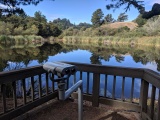
You may also want to use the wheelchair-accessible
viewing station to the right, before resuming the loop. Pond Loop Trail
continues on a flat course, under Monterey pines. At the edge of the pond, you'll
reach a signed junction and wheelchair-accessible pit toilet. Turn right,
following along the shore of the pond. This is the best place to look
for crayfish (best bet is when the water level is low), in the muddy shoreline. From about mid-way
across the dam, look downhill to a rock formation -- native American grinding stones are visible.
Pond Loop Trail curves right near some oaks, then crosses a bridge and
reaches a signed junction with a trail that crosses Alpine Road. Continue
to the right. Look for the pretty silvery leaves of white poplars to the
left, and blackberry bushes on the right. You may see or hear quail in
the dense undergrowth. Pond Loop Trail meets Ridge Trail at a previously
encountered junction. Turn left and retrace your steps (or wheel tracks)
to the trailhead.
Total distance: 0.5 mile
Last hiked: Friday, August
4, 2006