A
preserve that blends Santa Clara valley views with remnants
from a Jesuit sanctuary and a pistol firing range, St. Joseph's Hill Open
Space Preserve is popular with local dogwalkers, runners, and cyclists. Los Gatos is nestled just north of the preserve, and you can hike into
St. Joseph's from that town's Novitiate Park. Lexington Reservoir, a popular
fishing spot, sits to the south: the reservoir and southwestern portion
of St. Joseph's is managed by Santa Clara County. St. Joseph's western
border is CA 17, and traffic noise (especially trucks downshifting for
the grade) is a companion on some trails. Directly east (through Lexington
County Park) is MROSD's huge and rugged Sierra Azul Open Space Preserve,
dominated by 3,486 foot Mount Umunhum.
St. Joseph's is small, but features a few
short steep trails, and a couple options for loops. All hikes starting
at Lexington Reservoir climb on Jones Trail, but once in MROSD territory
you can choose 3 loops all around 3 miles. Whatever trails you choose, be sure to wear sturdy footwear, because the trails are rocky.
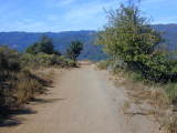
 For the featured hike, start at the Lexington
Reservoir parking lot. Cross Alma Bridge Road and begin walking uphill
on Jones Trail, marked by a SJ03 gate. This old, crumbly once-paved
road, open to hikers, cyclists, and equestrians, shoots straight uphill,
lined with eucalyptus, broom, and sagebrush. The steepest bit is over
after 0.15 mile, and the grade tapers off (as well as the pavement) near
a MROSD information signboard, where you can check your progress on a
map. As Jones Trail edges along a hillside parallel to CA 17, look for
cercocarpus, scrub oak, toyon, hollyleaf cherry, black sage, sticky monkeyflower,
pitcher sage, and chamise. In summer, puffy-winged seed pods on clematis
vines are conspicuous. A curve in the trail affords a lovely view
back to Lexington Reservoir, and the forested slopes of the Santa Cruz Mountains.
California bays thrive at a bend in the trail, creating a pleasant shaded
stretch, but then Jones Trail returns to sunny (and hot) chaparral. Two
opposing signs mark the transition from Santa Clara County managed land
to MROSD. You may see silktassel, a shrubby plant with unusual catkins
and evergreen wavy leaves; it grows in abundance at St. Joseph's. At 0.5
mile, Jones Trail meets Novitiate Trail at a signed junction. Jones Trail
continues north to Novitiate Park in Los Gatos. Turn right onto Novitiate
Trail.
For the featured hike, start at the Lexington
Reservoir parking lot. Cross Alma Bridge Road and begin walking uphill
on Jones Trail, marked by a SJ03 gate. This old, crumbly once-paved
road, open to hikers, cyclists, and equestrians, shoots straight uphill,
lined with eucalyptus, broom, and sagebrush. The steepest bit is over
after 0.15 mile, and the grade tapers off (as well as the pavement) near
a MROSD information signboard, where you can check your progress on a
map. As Jones Trail edges along a hillside parallel to CA 17, look for
cercocarpus, scrub oak, toyon, hollyleaf cherry, black sage, sticky monkeyflower,
pitcher sage, and chamise. In summer, puffy-winged seed pods on clematis
vines are conspicuous. A curve in the trail affords a lovely view
back to Lexington Reservoir, and the forested slopes of the Santa Cruz Mountains.
California bays thrive at a bend in the trail, creating a pleasant shaded
stretch, but then Jones Trail returns to sunny (and hot) chaparral. Two
opposing signs mark the transition from Santa Clara County managed land
to MROSD. You may see silktassel, a shrubby plant with unusual catkins
and evergreen wavy leaves; it grows in abundance at St. Joseph's. At 0.5
mile, Jones Trail meets Novitiate Trail at a signed junction. Jones Trail
continues north to Novitiate Park in Los Gatos. Turn right onto Novitiate
Trail.
The ascent picks up a bit, as the multi-use
trail climbs along an ugly chain-link fence at the preserve boundary.
Thick stands of tall manzanita shrubs crowd the trail, which winds uphill
and reaches a signed junction at 0.7 mile. Turn right onto Manzanita
Trail.
This aptly-named trail easily climbs along
the contour of a hillside, initially through California bays, a buckeye
or two, and some coast live oak. You'll soon enter a landscape dominated
by manzanita, with some black sage, silktassel, toyon, chamise, and scrub oak keeping the manzanita company. At 1.10 miles, Serpentine Trail departs on the left. Continue straight.
The wide path offers wonderful views
of the reservoir, and an unfortunate glimpse of an ugly quarry to the
 south. This eyesore, which surely takes away from the beauty of the Sierra
Azul, makes me think of an anatomy illustration; the "skin"
removed from the mountain reveals bare rock that resembles a bundle of
muscles. Traveling away from CA 17, traffic noise abates, and your
hike gains some peace and quiet. You may notice serpentine rocks lending
a greenish color to the sides of the trail. At 1.4 miles, Manzanita Trail
meets Range Trail at a signed junction. The flat clear spot to
the left, backed by a berm, is the old pistol range. Yellow star thistle
has invaded this treeless patch. Bear right to stay on Manzanita Trail.
south. This eyesore, which surely takes away from the beauty of the Sierra
Azul, makes me think of an anatomy illustration; the "skin"
removed from the mountain reveals bare rock that resembles a bundle of
muscles. Traveling away from CA 17, traffic noise abates, and your
hike gains some peace and quiet. You may notice serpentine rocks lending
a greenish color to the sides of the trail. At 1.4 miles, Manzanita Trail
meets Range Trail at a signed junction. The flat clear spot to
the left, backed by a berm, is the old pistol range. Yellow star thistle
has invaded this treeless patch. Bear right to stay on Manzanita Trail.
As the trail continues to wind gently uphill,
oaks, and then grassland overtake the chaparral community. At
1.6 miles, a shortcut trail departs to the left at an undersigned junction.
Remain to the right on Manzanita Trail.
After a straight stretch, then a sharp curve
left, Manzanita Trail sweeps uphill to the level summit of St. Joseph's
Hill. When it's clear, expect to see Mount Hamilton to the east, and the
Santa Clara Valley. There's also an unobstructed view of Mount Umunhum,
but I think this close-up vista pales in comparison to the
views from other south bay parks such as Calero
and Almaden Quicksilver. Jesuits
first lived on top of this hill in 1888; they planted grapes and
made wine, in addition pursuing spiritual devotion. Once
past the summit, the trail heads downhill through coyote brush, toyon,
poison oak, and broom. Look for buckwheat in bloom in late summer. At
2.1 miles, an unsigned path heads uphill to the left. Continue straight.
The trail turns right and descends somewhat steeply.
Ignore a path doubling back to the right at 2.2 miles. Unlike the chaparral
on the dry exposed hillsides on the south side of the hill, here the vegetation
is mostly comprised of shade loving plants including madrone, coast live
oak, California bay, and blackberry. At 2.3 miles, you'll reach a multiple
junction. Novitiate Trail to the right, is not a through trail, and ambles
uphill for 0.5 mile before ending. Continue straight.
Once more, a chain-link fence defines the
preserve border to the right, and manzanitas, eucalyptus, coast live oak,
some young Douglas fir, and toyon line the trail. At 2.5 miles, you'll
reach the previously encountered junction with Manzanita Trail. Continue
straight, and retrace your steps back to the trailhead.
Total distance: about 3.2 miles
Last hiked: Monday, October 14, 2002
Previous visit: October 4, 2000