 Bay Area Hiker's Guide to Point Reyes
Point Reyes is the premier bay area hiking destination for both tourists and locals. The peninsula and surrounding area has it all: trails through miles of wilderness, a variety of lodging, and spectacular food.
I've been visiting Point Reyes for more than 20 years, and it'll likely take me 20 more years to hike every trail and try out all the inns. On this page I'm sharing my experiences so you can get the most out of your Point Reyes trips.
Hiking:
Point Reyes National Seashore hosts about 150 miles of trails, and adjacent county, water district, and state parks contribute many more options.
Short and easy hikes:
Earthquake: departs from the Bear Valley Visitor Center. An easy 1/2 mile interpretive loop educates hikers on the San Andreas Fault.
Kule Loklo: departs from the Bear Valley Visitor Center. With only slight elevation change, this 0.8 mile out and back trail leads to a reconstructed Miwok village.
Woodpecker: departs from the Bear Valley Visitor Center. A nearly-level 1.6 mile tour through woods.
A bit tougher than easy, but still mild:
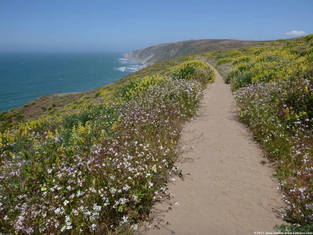
Chimney Rock: spectacular wildflowers in April and May. This 1.8 mile out and back hike at the south-east tip of Point Reyes has exceptional ocean views.
Bull Point: 3.8 mile out and back through cattle grazed-land, good spring flowers on this lonely trail.
Half-day hikes:
Mount Wittenberg: departing from the Sky Trailhead, this 5 mile partial loop climbs through woods to Point Reyes' highest hill.
Muddy Hollow: easily accessed via Limantour Road, this 7.4 mile loop is a fantastic Point Reyes sampler hike, offering a little of everything. Woods, grassland, ocean views, elk, and coastal scrub.
Bear Valley to Arch Rock: one of the most popular hikes at Point Reyes, this 8.2 mile out and back hike starts at the Bear Valley Visitor Center and travels through woods and grassland to the Arch Rock area.
Five Brooks: departing from a trailhead favored by equestrians, trails here climb through very quiet woods. Expect to share the trails with horses.
Barnabe Mountain:
this is a hike at nearby Samuel P. Taylor State Park, a few miles east of Point Reyes. Lovely woods and fantastic views from Barnabe Mountain.
Day long treks:
Tomales Point: excellent ocean views and wildlife watching (lots of tule elk) on this 8.4
mile out and back hike to the tip of Tomales Point.
Alamere Falls: this 7.5 mile out and back hike leads to one of Point Reyes' most beautiful spots: lovely Alamere Falls, where Alamere Creek empties onto the beach in a dramatic display. The trailhead, reached from a dead-end road, is far from any other Point Reyes destination.
Estero: an 8.5 mile out and back hike through coastal scrub, following the shoulder of Drakes Estero to a tiny sliver of beach near the opening to Drakes Bay.
Focusing on local history:
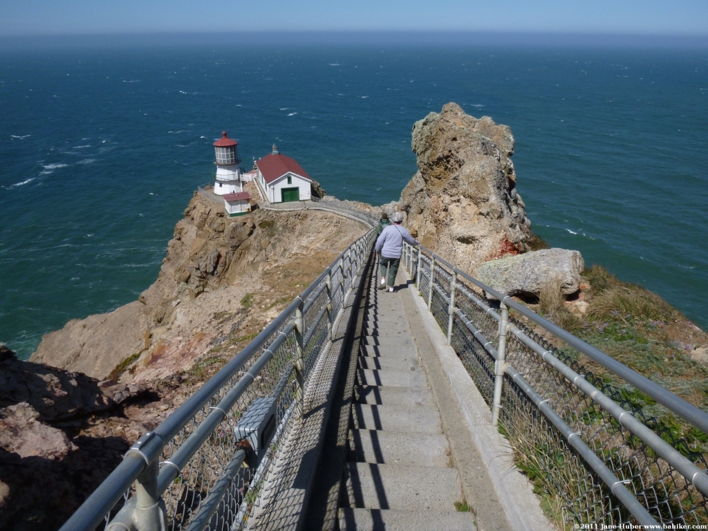
Lighthouse: this is the most remote Point Reyes trailhead. The trail starts out on a paved service road, then drops on a steep sets of steps to the lighthouse, where exhibits explain the history of the lighthouse. It's a brutal hike back up the steps, and the area is almost always exceptionally windy.
Wildflowers:
Chimney Rock: probably the most consistently impressive spot for wildflowers, this 1.8 mile out and back hike at the south-east tip of Point Reyes also has exceptional ocean views.
Wildlife:
Tomales Point: excellent ocean views and wildlife watching (lots of tule elk) on this 8.4
mile out and back hike to the tip of Tomales Point.
Chimney Rock: in addition to wildflowers and ocean views, sea lions and elephant seals are commonly spotted in this part of the park, and if you're lucky you might see a whale or two.
Bolinas Lagoon Preserve: a few miles south of Point Reyes, this small preserve is an excellent place to watch nesting egrets from mid-March to mid-July.
Ocean beaches (no hiking required):
Limantour:
South Beach
North Beach
Drakes Beach
Ocean beaches reached via trails:
Kehoe: mostly easy 0.7 mile (one way) hike along a creek, leads to sandy dunes and pretty beach.
McClures: 0.4 mile hike to beach.
Palomarin: short walk from the parking lot.
Tomales Bay hike-in beaches:
Marshall Beach: mostly used by locals, this is an easy hike to a calm Tomales Bay beach.
Indian Beach: just north of Hearts Desire Beach, inside Tomales Bay State Beach.
Hearts Desire Beach: the most popular bay-side beach with the best facilities, inside Tomales Bay State Beach.
Pebble Beach: lesser-known and rocky, inside Tomales Bay State Beach.
Shell Beach: reached via Johnstone Trail or from the end of Camino del Mar.
Chicken Ranch Beach: almost only used by locals or those in the know.
Millerton Point: a short trail on the east side of the bay.
Tomales Bay Trail: this trail descends through cattle pasture to the end of a salt marsh.
Scenic drives:
Lighthouse: a loooong drive from PRS, this route tours the southwest part of the park. During the winter, to reduce road congestion, you must take a bus to the lighthouse.
Tomales Point: spectacular views to the ocean from a high bluff. You can usually see elk without leaving your car.
Mount Vision: this narrow, dead-end road probably offers the most sweeping views of the peninsula, and is mostly overlooked by visitors.
Suitable to wheelchairs and strollers:
Earthquake: departs from the Bear Valley Visitor Center. An easy 1/2 mile paved interpretive loop educates hikers on the San Andreas Fault.
Abbotts Lagoon: wheelchairs and strollers should be able to navigate the first 0.4 mile.
Getting there:
There are three main options for driving to Point Reyes.
Most choose the straightforward route, exiting US 101 in Greenbrae and traveling west on Sir Francis Drake.
A second option, good for busy weekends, is to continue on US 101 north to Marinwood. Exit Lucas Valley Road and travel west to the junction with Nicasio Valley Road. Turn north (right) and continue to Point Reyes-Petaluma Road. Turn west (left) and travel to the junction with CA1. Turn left and you're on the outskirts of Point Reyes Station.
The third, and most scenic option, is to exit US 101 in Marin City, and travel north on CA1 to Point Reyes. This is by far the slowest route, but it is lovely.
Public transit:
Consult transit 511 for options, such as they are.
Books and maps:
Point Reyes National Seashore Trail Map, published by Tom Harrison Maps. Essential. Shows all Point Reyes trails as well as adjacent parklands.
Point Reyes, by Jessica Lage (order from Amazon). Very complete and useful, includes information regarding the history of Point Reyes.
Lodging:
Most accommodations are located in Point Reyes Station, Olema, and Inverness. There are motels, bed and breakfasts, inns, and guesthouses. Consider your plans when deciding where to stay: if you want to get takeout or eat in a sit down restaurant, you'll have more options in PRS, which can mean a considerable drive if you stay near Inverness.
This commercial site lists most Point Reyes lodging options.
Camping and backpacking:
There is no car camping in the park (there is a private family-oriented campground in Olema). The nearest state park with camping is Samuel P. Taylor, a few miles east of Point Reyes. If you want to backpack, there are several options within the park: read about the choices here.
Food:
In the past few years, the quality of food in and around Point Reyes has increased dramatically. Delightful, fresh, seasonal, and local foods are available and elevate a Point Reyes stay. Some of my favorites below.
Cowgirl Creamery: simply divine cheeses made from local West Marin milk. 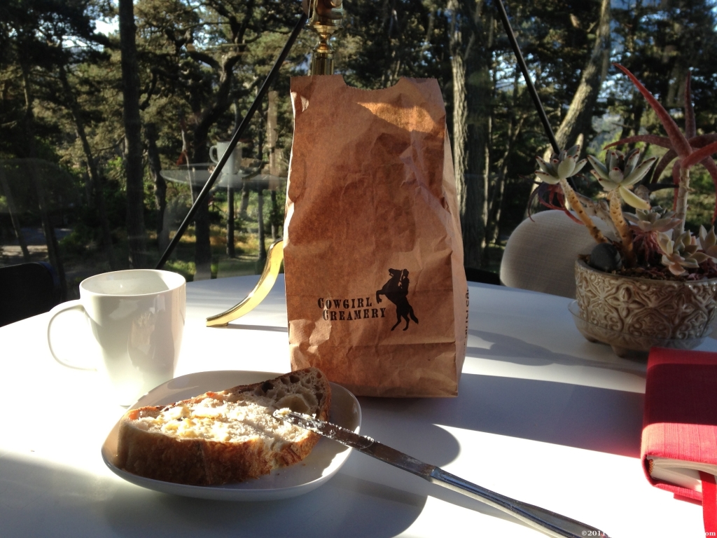 Triple creams, cheese rolled in herbs, wildflowers, chiles.... they are all incredible. Pair a cheese (or two) with Brickmaiden Bread and you have yourself a stellar meal. Cheeses are made and sold in the Tomales Bay Food building, right off the main street in PRS. Cowgirl sells prepared salads and sandwiches at their Cowgirl Cantina. In spring 2013 I stayed nearby and was a repeat customer, enjoying everything (but especially the chicken salad). Most highly recommended.
Brickmaiden Bread: some of the best bread I've ever eaten. Brickmaiden is sold in several Marin County markets and now they have a retail space in PRS.
Marin Sun Farms: My husband and I had lunch at MSF and it was incredible. Delicious burgers and water buffalo milk gelato from Petaluma’s Double 8 Dairy. Fantastic source of local grass-fed beef.
Palace Market: the largest grocery in PRS. Very good selection of basic items, nice meat counter, fresh veggies, and Brickmaiden Bread. If you need shampoo or wine, etc., this is the best choice in town. Secret detail: buy water buffalo gelato softserve in the meat department!
Inverness Park Market: this small business in Inverness has an extensive deli and offers complete meals to go. Convenient location if you're staying in Inverness or Inverness Park.
Farmers Market: every Saturday morning.
Bovine Bakery: for years this was my standard stop for a morning muffin (and a ham and cheese croissant for lunch) on the way to a trailhead. I confess I now prefer Brickmaiden Bread, but Bovine is still a good source for coffee and pastries.
Disclaimer: I have paid for every book, map, and piece of cheese described on this page. I've never accepted lodging in exchange for a review, but I will entertain any offers!
Copyright 2019 Jane Huber/Bay Area Hiker